Current Drought Conditions in the United States
Drought conditions improved across the U.S. over the past month, with particularly dramatic improvements in the West. The nationwide Drought Severity and Coverage Index (DSCI) decreased from 165 to 137, with decreases in the percent coverage of all drought categories (D0 – D4). California experienced impressive state-wide improvements due to multiple weeks of intense precipitation early in January, resulting in a 100-point decrease in the DSCI and providing extensive drought relief. Precipitation in California was over 300% of normal over the first two weeks of January, and the sum of California’s largest six reservoirs increased from 5 million acre-feet to 7.3 million acre-feet. Other parts of the West benefitted from the heavy rainfall as well, with large-scale improvements in the Pacific Northwest and Rockies. The Northeast continued to remain generally drought-free overall, and the Midwest experienced a decrease in drought across the region. The Southeast and South both saw decreases in drought conditions over the past month, however, drought conditions lingered along the coast in the Southeast, and intensified in Texas and Oklahoma in the South.
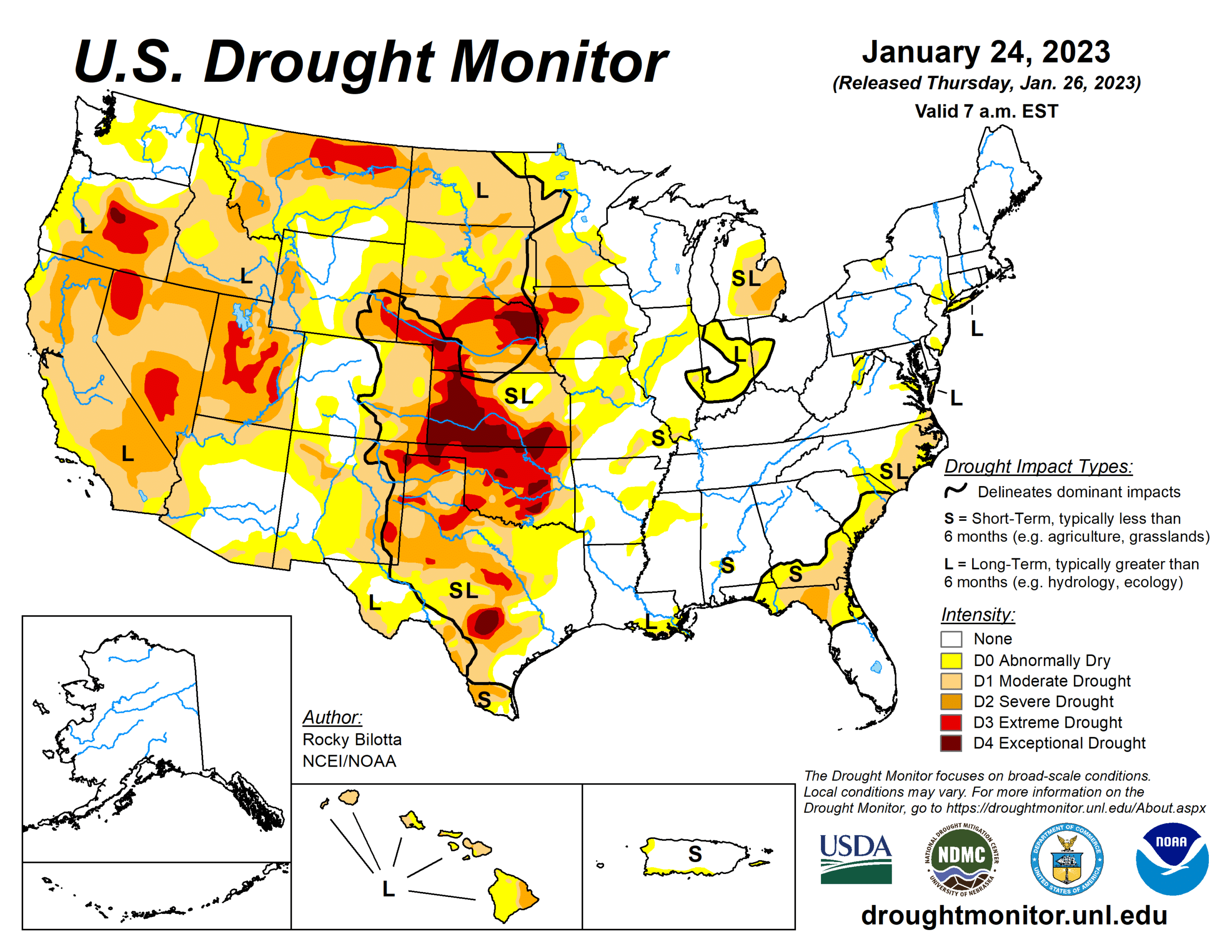
(The U.S. Drought Monitor is jointly produced by the National Drought Mitigation Center at the University of Nebraska-Lincoln, the United States Department of Agriculture, and the National Oceanic and Atmospheric Administration. Map courtesy of NDMC-UNL.)
Drought worsened in Texas over the last month. Extreme and exceptional drought conditions (D3 and D4) expanded in central Texas, and abnormally dry and moderate drought conditions (D0 and D1) increased in the Red River region in east Texas. The Panhandle continues to suffer from drought conditions ranging from severe to exceptional (D2 – D4) across the region, resulting in decreases in soil moisture and stream flow levels.
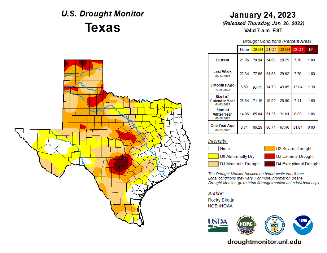
(The U.S. Drought Monitor is jointly produced by the National Drought Mitigation Center at the University of Nebraska-Lincoln, the United States Department of Agriculture, and the National Oceanic and Atmospheric Administration. Map courtesy of NDMC-UNL.)
Drought conditions in Oklahoma also increased as precipitation remained lower than normal over the past month. A large portion of the state is experiencing extreme and exceptional drought (D3 – D4), with only a small sliver of the eastern corner of the state remaining drought-free.
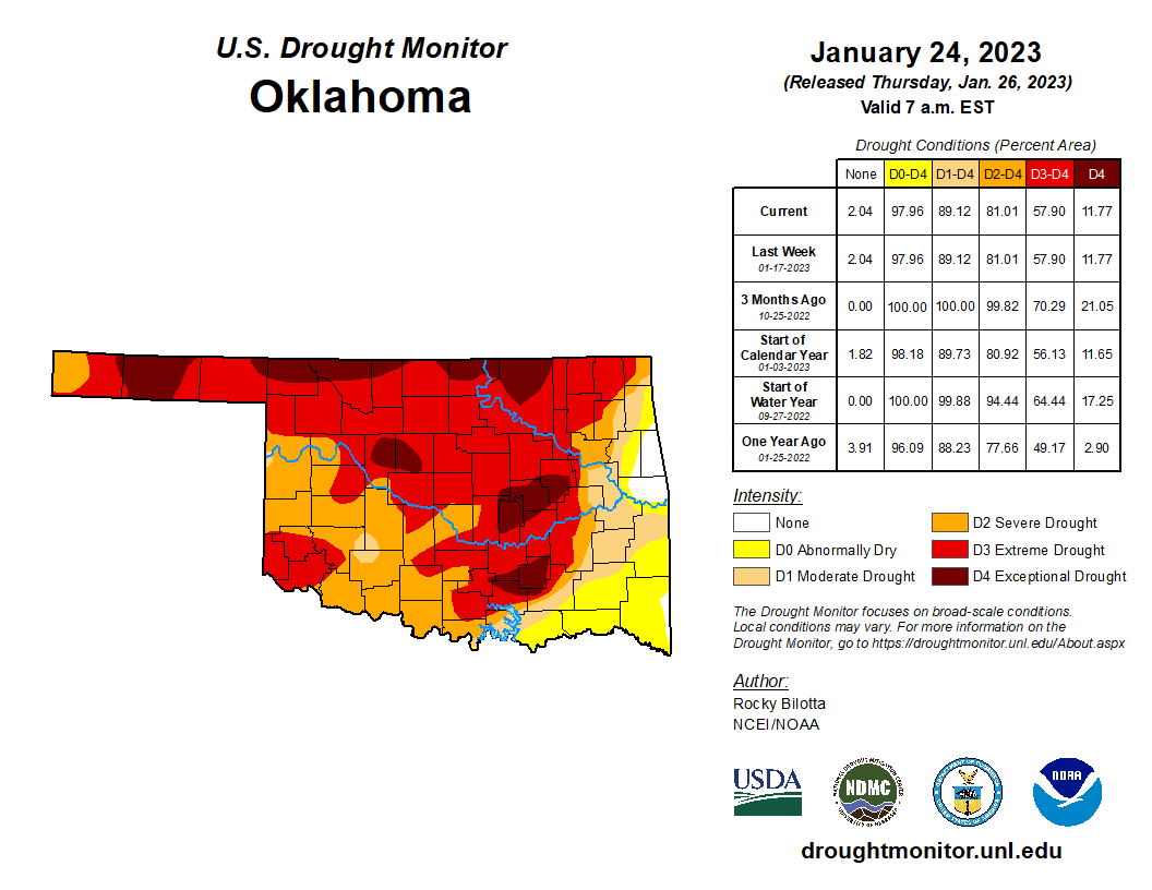
(The U.S. Drought Monitor is jointly produced by the National Drought Mitigation Center at the University of Nebraska-Lincoln, the United States Department of Agriculture, and the National Oceanic and Atmospheric Administration. Map courtesy of NDMC-UNL.)
Due to heavy rainfall in Louisiana, drought conditions significantly decreased across the state, particularly in northern Louisiana where moderate drought conditions (D1) were entirely eliminated.
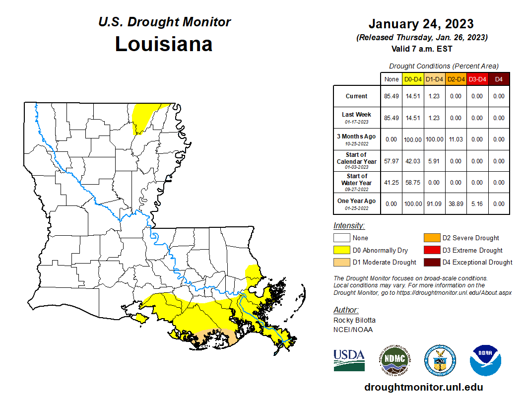
(The U.S. Drought Monitor is jointly produced by the National Drought Mitigation Center at the University of Nebraska-Lincoln, the United States Department of Agriculture, and the National Oceanic and Atmospheric Administration. Map courtesy of NDMC-UNL.)
Drought conditions decreased in New Mexico over this past month, with precipitation alleviating a swath of abnormally dry conditions (D0) in the western half of the state. The eastern half of the state continues to experience some patches of extreme drought (D3).
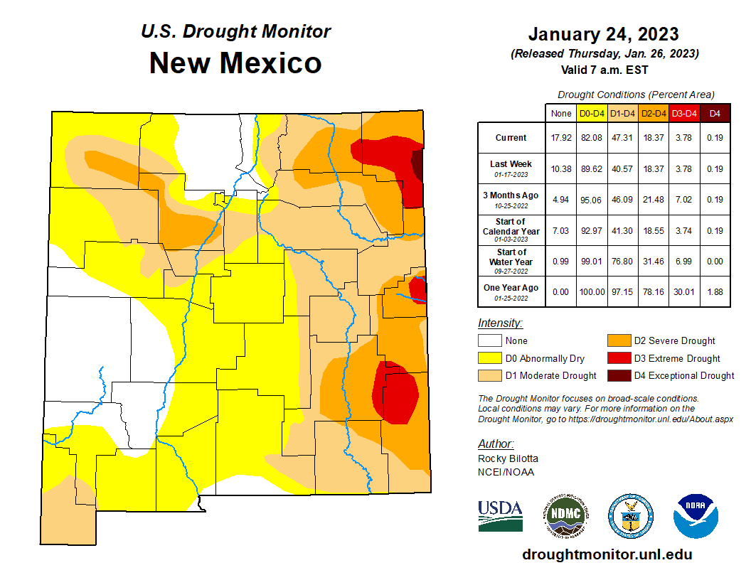
(The U.S. Drought Monitor is jointly produced by the National Drought Mitigation Center at the University of Nebraska-Lincoln, the United States Department of Agriculture, and the National Oceanic and Atmospheric Administration. Map courtesy of NDMC-UNL.)
Drought conditions decreased in Georgia due to heavy rainfall in the Southeast. The southern half of the state improved, with a large area of abnormally dry (D0) drought conditions decreasing.

(The U.S. Drought Monitor is jointly produced by the National Drought Mitigation Center at the University of Nebraska-Lincoln, the United States Department of Agriculture, and the National Oceanic and Atmospheric Administration. Map courtesy of NDMC-UNL.)
Florida also decreased in drought conditions over the last month. Most of the state continued to remain drought-free, and the patch of severe drought (D2) in the northern half of the state shrank in size.
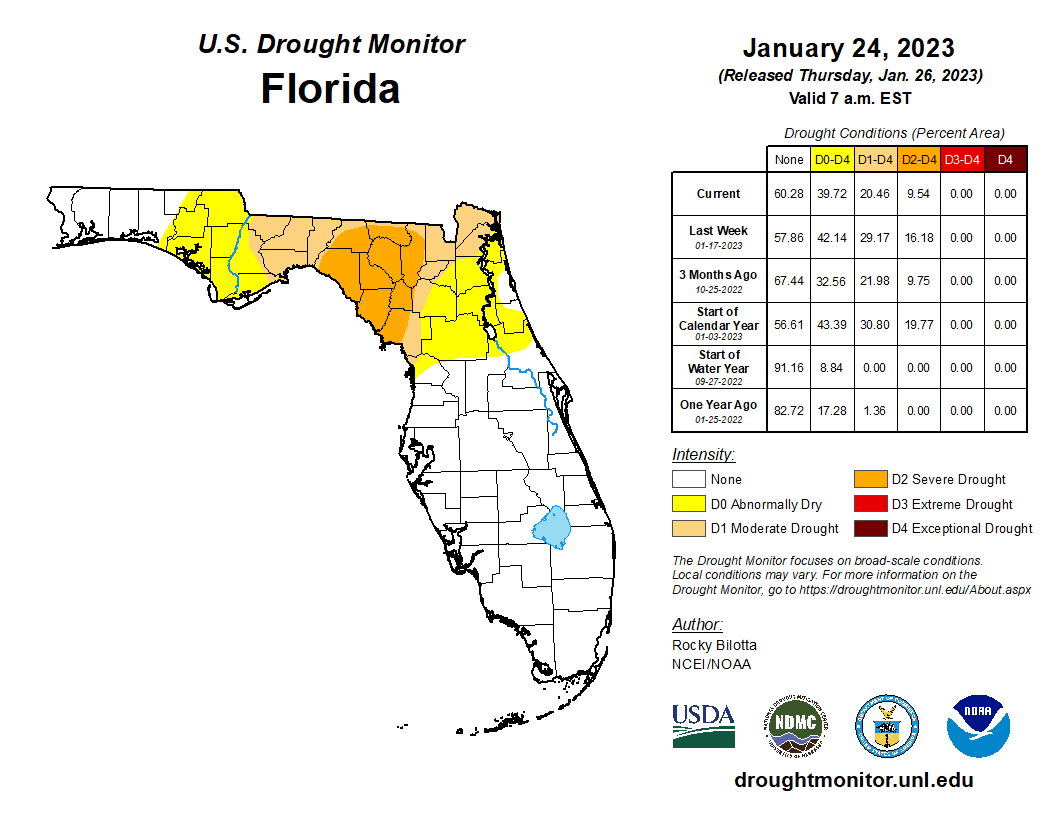
(The U.S. Drought Monitor is jointly produced by the National Drought Mitigation Center at the University of Nebraska-Lincoln, the United States Department of Agriculture, and the National Oceanic and Atmospheric Administration. Map courtesy of NDMC-UNL.)
Drought slightly decreased in North Carolina, however, an area of moderate drought (D1) persisted along the coast of the state.
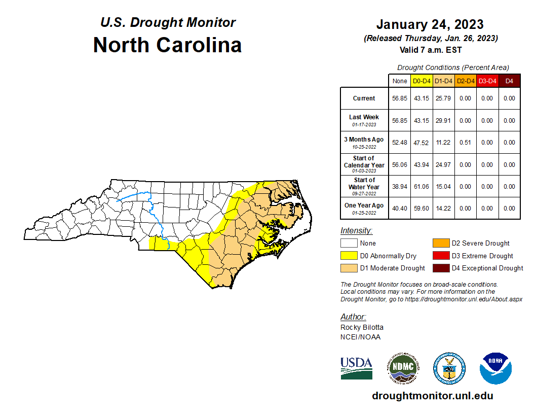
(The U.S. Drought Monitor is jointly produced by the National Drought Mitigation Center at the University of Nebraska-Lincoln, the United States Department of Agriculture, and the National Oceanic and Atmospheric Administration. Map courtesy of NDMC-UNL.)
Drought conditions slightly decreased in Virginia over the past month, and the majority of the state continues to remain drought free.
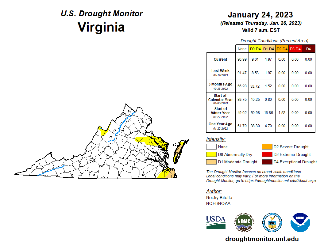
(The U.S. Drought Monitor is jointly produced by the National Drought Mitigation Center at the University of Nebraska-Lincoln, the United States Department of Agriculture, and the National Oceanic and Atmospheric Administration. Map courtesy of NDMC-UNL.)
Forecast
Over the next week, the eastern seaboard and the Southeast are predicted to receive heavy rainfall, particularly from east Texas up to Georgia. The coastal Pacific Northwest is forecast to receive precipitation as well, along with northern coastal California. Little to no rainfall is predicted for much of the High Plains and West, particularly the Dakotas and Nebraska. To check out the forecast near you, try the NOAA Quantitative Precipitation Forecast map.
Recommended Links
Drought Conditions in Texas and the United States
- U.S. Drought Monitor: Texas Drought Conditions Map
- Texas Commission on Environmental Quality (TCEQ): Drought Impact on Texas Surface Water Map
- Texas Water Development Board’s Water Data for Texas: Drought
- U.S. Drought Monitor: United States Drought Conditions Map
- National Oceanic and Atmospheric Administration (NOAA): Palmer Drought Severity Index
- TCEQ: Texas Drought Information
- Texas Forest Service: Outdoor Burn Bans Map
Reservoir Levels in Texas
- The Texas Tribune: Track Texas Reservoir Levels
- Texas Water Development Board: Reservoir Storage Information
Streamflow Conditions in Texas
Drought Restrictions in Texas
Additional Information and Data
Drought Conditions in Texas and the United States
- NOAA: Drought Maps and Data
- Office of the State Climatologist
- National Drought Mitigation Center: Vegetation Drought Response Index
Reservoir Levels in Texas
Streamflow Conditions in Texas
Groundwater Levels in Texas
Drought Restrictions in Texas
